GCOOS Data Provider Highlight: Texas Coastal Ocean Observation Network (TCOON)
The GCOOS-Regional Association (GCOOS-RA) is publishing an ongoing series of stories about our critically important data providers to the GCOOS Data Portal and Products. These data providers are the building blocks upon which GCOOS is based; many of these providers and their programs have been collecting and providing observational data individually before the formal existence of the GCOOS-RA. The GCOOS-RA brings these providers together and offers an integrated, more comprehensive view of the Gulf for stakeholders through our Portal and Products pages. GCOOS also provides many data providers with financial support for data management and operations and maintenance, as well as tools and standards to make their data more accessible and interoperable with other data sets.
Introduction to the Texas Coastal Ocean Observation Network (TCOON)

Figure 1. Map of TCOON Stations along the Texas Coast (Credit: TCOON)
The TCOON network, created by the Texas Legislature in 1989, is a network of 30 scientific data collection stations used to collect critical data on water levels, wind speed and direction, barometric pressure, and air and water temperature along the Texas coast. The network, which began in 1989, currently consists of 30 data collection stations from the Texas Mexico border to the Texas Louisiana border on the Sabine River (Figures 1 and 2).
TCOON is a partnership of federal, state, and local governmental entities, non-governmental organizations, and the Conrad Blucher Institute for Surveying and Science (CBI) at Texas A&M University-Corpus Christi. The government partners include the Texas General Land Office (TGLO), the Texas Water Development Board, the U.S. Department of the Interior, National Oceanic and Atmospheric Administration, the U.S. Army Corps of Engineers, and the U.S. Fish and Wildlife Service, who contribute to the construction, maintenance, and operation of TCOON. The NGO partner is the Gulf of Mexico Coastal Ocean Observing System Regional-Association (GCOOS-RA), which publishes TCOON data through the GCOOS data portal.
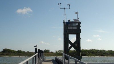
Figure 2. TCOON Station at Packery Channel, TX (Credit: TCOON)
TCOON stations and data management are designed to meet the rigid scientific guidelines of NOAA Center for Operational Oceanographic Products and Services (CO-OPS), which allows TCOON data to establish tidal datums admissible in court. Tidal datums are used in identification and defense of littoral boundaries, or legal boundaries along the seashore separating privately owned land from state owned submerged land. Moreover, detailed records provide an audit trail of the steps used in the collection and production of data products from TCOON, assuring the accuracy and reliability of these products.
In addition to the critical function of production of tidal datums, TCOON data are essential to public officials charged with hurricane preparedness, meteorologists providing storm forecasts, and research scientists monitoring the environmentally sensitive bays and estuaries in Texas and as input for water level, storm surge, and circulation models. “This information will help local, state, and federal agency officials make the best decisions regarding the flooding of evacuation routes, low lying areas, community infrastructure, and public safety,” said James Rizzo, CBI Assistant Director of Operations. “The data will also assist researchers from the National Ocean Service, the National Weather Service, the National Hurricane Center by providing accurate, federally-approved data used in water level and storm surge forecasting.” The data are also accessible to the general public, and are frequently accessed by recreational and commercial users such as wind surfers, sailors, anglers, and surfers. Data from TCOON stations are collected in near real-time and provided to users via the TCOON web interface (http://www.tcoon.org/), the Gulf of Mexico Coastal Ocean Observing System (GCOOS) Data Portal (http://data.gcoos.org), a dial in phone system known as WindInfo (361-992-WIND) or via Facebook and Twitter feeds (Figure 3.)

Figure 3. Example data plot of water level from TCOON station at Rollover Pass, TX from the GCOOS Data Portal
TCOON Success Stories
The CBI is frequently called upon by local, state, and federal agencies to provide data for hurricane response. TCOON stations located along the Texas Coast collect, process, and disseminate data to users through the TCOON web portal and to emergency responders immediately once processing is complete. All TCOON data is collected and transmitted every six minutes via Internet Protocol devices and satellite transmitters. During Hurricane Rita in 2005, TCOON stations remained operational and provided critical information on water levels at the Texas Coast. At Rollover Pass, at the height of the storm surge, water levels reached 1.6 meters above mean sea level (Figure 4.). TCOON provided important information before, during, and after the storm.
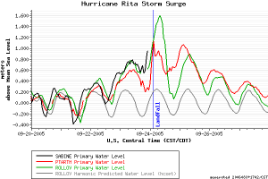
Figure 4. Water levels measured at Sabine Pass, Port Arthur, and Rollover Pass TCOON stations during Hurricane Rita, 2005 (Credit: TCOON)
In preparation for the 2013 hurricane season, TCOON added five stations at High Island, Galveston Railroad Bridge, Matagorda City, Sargent, and Aransas Wildlife Refugeto enhance the data set used to support public safety decisions before, during, and after the passage of a hurricane or tropical storm. CBI personnel developed specialized software to allow the local National Weather Service Office to seamlessly integrate near real-time observations into its weather forecasting systems to better predict the effects of an oncoming storm.
CBI researchers designed and implemented two applications for mobile devices using the TCOON data. The first, the “Transit Time” app, provides ship captains and harbor pilots with real-time predictions of ocean water levels and currents in the Houston Ship Channel. The app is based on National Oceanic and Atmospheric Administration hydrodynamic predictions, which is combined with information from the vessel to predict the future positions of the ship as it transits along the channel. Get the app at http://cbi-apps.tamucc.edu/transit.
The second mobile application, the “Texas Coastal Winds” app, provides coastal users with the latest wind information along the Texas coast. This phone app uses wind measurements collected by TCOON stations that are sent to TCOON servers and from there to the app users who are provided near real-time wind speeds and directions relative to their location. The “Texas Coastal Winds” app can be accessed as a webpage at http://cbi-apps.tamucc.edu/tcw or can be downloaded from Google Play.
In July 2014, CBI received $1.35 million from the National Geodetic Survey of NOAA to collect sea level data used in updating Flood Insurance Rate Maps. The study, led by Dr. Gary Jeffress at CBI, will use the sea level data collected by TCOON stations to measure the difference in elevation points along the Gulf Coast and inland to make more accurate maps. The sea level project focuses on areas most exposed to inundation from tropical storm surge, with a high risk of flooding from the long-term effects of climate change and subsidence. The project will provide additional measurements, including more accurate data about elevations, subsidence rates, and land elevation points for ongoing monitoring of the relative sea level change along the northern Gulf of Mexico for the coming decades. The data will also benefit coastal resiliency planning along the Gulf Coast, Jeffress said.
Next Steps
To augment the current TCOON, CBI was recently awarded a $2 million grant from the Texas General Land Office to install four “Sentinels of the Coast” data collection stations (Figure 5.). They are designed, in conformance with NOAA standards, to withstand the effects of a Category Four hurricane and will collect water level and meteorological data. The CBI will oversee the design, construction, and installation of each structure. Upon completion, CBI will install equipment and initiate operation and data collection from these new TCOON monitoring stations.
“These new TCOON stations will allow for monitoring conditions before, during, and after a hurricane has made landfall,” said Rizzo. “The data will be used by local National Weather Service and National Hurricane Center personnel for forecasting models. The data will be an invaluable resource to local, state, and other federal agencies before, during, and after storm events to assess damage along the coast and to the waterways of the Texas coast.”
Rizzo noted that after the storm, the information will be used by numerous agencies as they assess damage along the coast and to the waterways of the Texas coast. The stations will provide accurate, real-time water level, wind speed, direction, and gust information, barometric pressure, and temperatures.
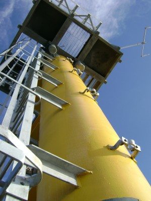
Figure 5. Sentinel of the Coast TCOON station Galveston Bay Entrance, North Jetty
The Sentinels should be operational by July 31, 2015. The new TCOON stations will be located at Surfside (Freeport), Port Aransas, the Matagorda Ship Channel (near Port O’Connor), and South Padre Island, all critical locations along the coast. Each station will include instrumentation located approximately 30 feet above sea level.
TCOON and GCOOS
The Conrad Blucher Institute is a member of GCOOS-RA. The GCOOS-RA also provides data management funding to TCOON and serves the TCOON data from the GCOOS data portal (http://data.gcoos.org). In the future, the GCOOS-RA plans to publish the new Sentinel TCOON data when it comes online.
Learn More
For more information, contact Robin Ellis at robin.ellis@tamucc.edu or visit the TCOON website at http://www.tcoon.org/ .
Article From GCOOS
http://gcoos.org